

Snowdon Guide
Snowdon's (Yr Wyddfa) routes
All of the paths up Snowdon are mountain routes that take hours to get up and down. From easiest to hardest the footpaths are:
-
Llanberis Path (Easiest)
-
South Ridge (Hardest)
Easiest Snowdon route
The Llanberis Path is generally considered the easiest route up Snowdon but it is also the longest.
The gradient is the least steep so it is the least strenuous and the footpath is quite good for a mountain track. If you haven't spent much time in the British mountains before and can't navigate using a map and compass we recommended you get a guide.
Hardest route up Snowdon
In terms of walking the hardest route up Snowdon is the South Ridge.
It is the most difficult because it is the steepest, roughest and scariest. It starts at a lower elevation than the other walks, therefore has the most height gain from the car park to the summit and the narrow ridge at the end is a test of bravery.
In addition to this, Crib Goch is a popular (Grade 1) scrambling route to access the summit of Yr Wyddfa (Snowdon). Be aware that it is extremely challenging and consequential and requires experience, skill and a good head for heights.
Which route should I take?
There are 6 main hiking routes up Snowdon with the Llanberis Path being the easiest.
If you want a physical challenge of fitness and endurance then the Watkin Path is a good choice.
For an exhilarating adventure with steep rocky sections of scrambling while the world plunges below you as you navigate a high ridgeline then the South Ridge is for you. A proper mountain adventure!
All the routes have fantastic views but the best are the Ranger Track, Miners & Pyg Track and The South Ridge.
If you want to nip up and down as quickly as possible the Pyg Track & Miners Track can be the fastest but not the easiest.
Which Snowdon path has the best views?
"Beauty is in the eye of the beholder".
-
The South Ridge
-
The Pyg Track & Miners Track
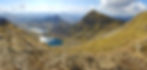
Snowdon is rich in amazing views and vista from the summit is spectacular when the weather permits. Each route has different highlights, but Walk Snowdonia's top two are the South Ridge and the Pyg Track.

The South Ridge
1. The South Ridge hike starts in ancient woodland and follows the 'Afon Cwm Llan' river and it's waterfalls before joining the ridge itself which has spectacular views for over two kilometers making it a top choice.
Interest is sustained throughout making this one of the most picturesque routes up Snowdon. The higher you get the more dramatic things become, culminating in the narrow rocky ridgeline of Bwlch Main.

The Pyg & Miners Track
2. The Pyg Track is a rugged mountain hike situated in an amphitheatre of rocks and mountains which make up the infamous Snowdon Horseshoe
The route passes the lakes of Llyn Llydaw and Glaslyn with great views of the summit of Snowdon. The route increases in steepness as the top of the valley climaxes between the two highest mountains in Snowdonia; Snowdon (1085m) and Garnedd Ugain (1065m).
The height, commanding position and other mountains linked by dramatic cliffs make this one of the best views that Snowdon has to offer
Other Scenic Snowdon views
There are plenty of incredible views on Snowdon. Here are some highlights from each footpath...
Rhydd Ddu Path
-
Expansive views across the Nant y Betws valley and it's lakes
-
Great view of the Nantalle Ridge
-
Scenic ridge walk
Watkin Path
-
Epic views of Cwn Tregalan and the cliffs of the South Ridge
-
River and waterfalls
-
Slate quarry
Miners Track
-
Cross the causeway of Llyn Llydaw lake
-
Touch the waters of the legendary lake Glaslyn
Ranger Path
-
Spectacular views down the Cwm Clogwyn valley and across to Llechog and Bwlch Main ridge
-
Passes the Llyn Ffynnon-y-gwas reservoir
Llanberis Path
-
Best views of the cliffs of Clogwyn Du'r Arddu and its lake
-
Fantastic view of the Glydders and Llanberis pass at the Clogwyn Station
-
Mountain railway
How hard is Snowdon?
Snowdon is a challenging uphill hike on mountain footpaths. Most reasonably fit and healthy adults can walk up and down Snowdon in the right conditions.
Over half a million people of all ages climb Snowdon every year. It is thought that the oldest person to successfully climb the mountain was Ron Barnes at 84.
That said, it is still a mountain and if this is your first time climbing one we recommend getting a guide
More information about How Hard is Snowdon?
How long does it take?
It takes the average walker 6-8 hours to get to the top and back down. This time includes about 4 hours walking uphill, and 2 or 3 hours to walk back down. Depending on the route and your level of fitness, it might take more or less time.
The footpaths vary in quality, are rugged mountain tracks and are steep in places. These sections can slow things down. especially if fitness is an issue.
How fit do you need to be for Snowdon?
If you are not sure then please don't hesitate to contact us or you can book your own Private Guide who will be able to take you up there at your own pace.
When is the best time to climb Snowdon?
June, July and August are usually the best months to walk up Snowdon. The weather is generally warmer and you are more likely to get a clear day to enjoy the magnificent views from the summit. The longer days give you more time to get up and down. That said, the weather can be freezing cold, with driving rain/ hail and ferociously windy at any time of the year.
Check out our statistically researched blog article to see the best month to climb Snowdon for weather, views, quiet footpaths and more.
There is no best time of the day to walk up Snowdon. Remember that it takes 6-7 hours on average to get to the top and back down so make sure you leave yourself plenty of daylight. Generally speaking, the earlier you start the better as you will have more daylight.
What equipment do I need for Snowdon?
To walk up Snowdon in summer conditions (no snow or ice) you will need:
Essentials
-
A guide or a map and compass (and knowledge of how to use them)
-
Walking boots (or robust trekking shoes)
-
Waterproofs (jacket is essential trousers are highly recommended)
-
Rucksack (25L)
-
Suitable walking clothes (no jeans)
-
Warm clothes (an extra fleece, a hat and gloves)
-
Food and water
Highly recommended
-
First aid kit
-
Mobile phone (fully charged)
-
Headtorch
Prepare for the worst and hope for the best. It is often cold and wet on the summit of Snowdon even on a nice summers day.
When is Snowdon open?
The paths up Snowdon are open all year. However, you should stick to the summer months (April- October) unless you are an experienced mountaineer with winter mountaineering kit such as ice axes and crampons.
Where to park for Snowdon?
It depends on which route you are taking.
The best place to park to walk up Snowdon is the village of Llanberis (start of the Llanberis Path). There is more parking here than at the start of any other route.
Route: Llanberis Path
Carpark: Llanberis
Llanberis Path Parking
Postcode: LL55 4TD
Start point: Village of Llanberis
Cost: £14
After this, the village of Rhyd-Ddu also has a decent-sized pay and display car park but this does fill up on busy days with nowhere else to park nearby.
All of the other routes have car parks but spaces are limited and the local council hand out dozens of fines on busy weekends to people parking illegally.
You can park at the car parks at the foot of Snowdon and use The Snowdon Sherpa bus to get around.
Where do I start Snowdon?
It depends on your route. A popular place to start your walk-up Snowdon is from the village of Llanberis. There are lots of car parks in the village and the Llanberis footpath is the easiest in terms of difficulty and navigation. It is also the busiest.