Snowdon
Ranger Path
At a glance
Difficulty: Moderate
Distance: 8 miles (13km)
Ascent: 940m
Time: 6-7 hours
Crowds: 3/10 (Quiet)
Fear factor: 1/10 (Not scary)
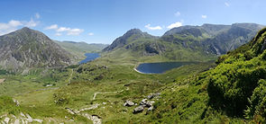
The Ranger Path is one of the quieter and less difficult climbs up Snowdon. Don’t let this fool you though. The Ranger Path has great views especially when it joins the shoulder of Clogwyn Du’r Arddu.
It is believed that the Snowdon Ranger Path is the oldest of the six classic routes to the summit. It is named after John Morton who was known as ‘The Snowdon Ranger’ who during the 19th century guided Victorian tourists to the top of the mountain.
Snowdon Route: Ranger Path

Who is it for?
The Ranger Path is one of the easiest routes up Snowdon so is perfect for most people who can walk at a steady pace for around 7 hours. We will be taking regular short breaks.
We accept children of 13 years and over on our Group Walks. Anyone under the age of 18 has to be accompanied by a parent or legal guardian at all times. Please contact us to arrange a Private Guiding walk for parents and children under 13 years of age.
What equipment do I need?
We will send you a detailed kit list upon booking and again shortly before the event.
Normal hiking gear is needed and this varies a little depending on the time of year and the forecast on the day. Items that are always required which you may need to go out and buy include walking boots/ walking shoes (not trainers), a waterproof jacket and a rucksack.
We can give you advice about what to buy if you have booked onto one of our walks.
Where does it start?
We will send you out detailed Event Notes by email before the walk which include where and when to meet and parking instructions.
Instructors
All of our instructors are fully qualified Mountain Leaders with a minimum of a 16 hour First Aid certificate. All participants are covered by our Public Liability Insurance.
The Ranger Path Route Description
The Snowdon Ranger Path begins at the Llyn Cwellyn pay and display car park just off the A4085. Follow the signs for the bridleway and take the path over the railway until reaching the farmhouse. After the farmhouse the path forks. Take the right fork and the path will soon zigzag up mountain pasture. Here the gradient is gentle and the recently rebuilt footpath is excellent. After the zigzags, the gravelly path continues at a gentle gradient until it reaches the Llyn Ffynnon-y-gwas reservoir.
The next section of the climb is the toughest and steepest as the footpath zigzags again for 200m as it starts to ascend up the shoulder of Clogwyn Du’r Arddu. Your hard work is rewarded with impressive views down the Cwm Clogwyn valley and across to Llechog and Bwlch Main ridge.
After the zigzags, the rocky scree path continues more directly passing numerous cairns. The terrain becomes very baron so route finding here is difficult, particularly in poor conditions. The gradient lessens and the terrain eventually becomes grassy as the shoulder above Clogwyn Du’r Arddu widens. The views improve as you ascend and the footpath crosses the Snowdon Mountain Railway and shortly after this the Ranger Path converges with the Llanberis, Crib Goch and Miners/ Pyg Track paths for the final push to the summit.
Here the views of Snowdonia are spectacular. On a clear day, you will be able to see the knife-edge ridge of Crib Goch and Y Lliwedd as well as the Lakes of Llyn Llydaw and Llyn Peris and dozens of beautiful and rugged mountains which make up the National Park of Snowdonia.