

Pyg & Miners Track: The Ultimate Circular Route Guide
- Mar 16
- 13 min read
Updated: Apr 11
The Pyg & Miners Track is the shortest walking route to the summit of Yr Wyddfa (Snowdon), steeped in history and one of the most spectacular.

Is Pyg/Miners Circular Snowdon’s Best Route?
If you only do one walk on Snowdon (Yr Wyddfa), this is an excellent choice.
The Pyg Track and Miners’ Track circular takes two of the mountain’s finest paths and links them so you can squeeze them both into a single day. You climb through dramatic mountain scenery on the Pyg Track, stand on the highest point in Wales, then descend past stunning glacial lakes on the Miners’ Track.
The route passes directly beneath the fearsome Crib Goch ridge, crosses the shore of the blue-green Glaslyn lake, and finishes with a flat stroll across the famous Llyn Llydaw causeway. You get big mountain drama on the way up and a gentler, lake-filled return on the way down.
This is one of our most popular guided walks and it is easy to understand why. We walk this route every week and it never disappoints.
Not sure if this route is right for you? Get in touch to learn more.
Everything you need to plan this walk is below: parking, transport, a step-by-step route description, honest advice on difficulty, and a kit list.

PYG/ Miners Circular: Quick Facts at a Glance
Total Distance | 7.5 miles / 12 km |
Total Ascent | 723m |
Estimated Time | 5 to 7 hours (including summit stop) |
Difficulty | Slightly Challenging |
Start / Finish | Pen y Pass car park, LL55 4NY |
OS Map | Explorer OL17 Snowdon & Conwy Valley |
Highest Point | Yr Wyddfa (Snowdon) summit, 1,085m |
Recommended Direction | Pyg Track up, Miners’ Track down |
Getting There: Pen y Pass Parking & the Sherpa Bus
Parking is the single biggest source of frustration for anyone planning a Snowdon circular walk from Pen y Pass.
The car park is small, demand is enormous, and if you do not plan ahead; at best you could waste the first hour of your day driving around trying to park and at worst you could get a parking ticket or even towed! Here is how to get it right.
Pen y Pass Car Park: Pre-Booking and Costs
Pen y Pass car park sits right at the trailhead for both the Pyg Track and the Miners’ Track, at the top of the Llanberis Pass. It holds around 66 vehicles which is nowhere near enough for the number of walkers who want to start here.
From late March to early November, you must pre-book your space through JustPark.
You cannot turn up and pay during the pre-booking season. Bookings must be made at least one hour in advance, and popular weekends sell out weeks ahead.
Pen y Pass parking costs (2026 pre-booking season):
Up to 8 hours: £25
8 to 12 hours: £35
12 to 24 hours: £45
You will need to enter your vehicle registration when booking. The car park is staffed 24 hours a day.
Outside the pre-booking season (November to late March), parking switches to pay and display at £15 per day on a first come, first served basis. On fine winter weekends, it can still fill up well before 7am. If it is full when you arrive, use one of the alternatives below.
Pen y Pass car park
LL55 4NY
What3Words: brush.ringers.recline
Important: The road around Pen y Pass is a clearway. You cannot park on the road and vehicles are regularly towed. Do not risk it.
Park and Ride from Nant Peris
If Pen y Pass is full or you want to save money, the Nant Peris park and ride is your best option.
The car park is large, costs just £5 for the day, and accepts card or cash.
From Nant Peris, the Snowdon Sherpa’r Wyddfa bus runs regularly up to Pen y Pass. During the high season (late March to early November), the S1, S2 and S5 services combine to provide a bus roughly every 15 to 30 minutes. The ride takes about 10 minutes. Tickets are bought on the bus and contactless payment is accepted, with fares ranging from £3 for a single to £4.50 for a return.
Plan an extra 15 minutes onto your day for the bus connection each way. It is well worth it for stress-free parking.
Alternative Parking at Pen y Gwryd
There is a small lay-by on the A498 just east of the Pen y Gwryd Hotel that offers free but very limited roadside parking.
From here, a permissive footpath leads up to Pen y Pass in around 20 to 30 minutes each way. It is a pleasant walk along a quiet path and a good backup if everything else is full. This adds roughly an hour to your day.
Be aware that there is also a pay & display system just outside and to the south of the Pen y Gwryd Hotel. Cars parked inside the pay & display area (which isn’t obvious or clearly marked) that don't pay & display receive parking fines. It is patrolled everyday!
If you are planning a summer walk, arriving before sunrise is the surest way to beat the crowds. Take a look at our Snowdon sunrise guide for tips on dawn starts.

The Pyg Track: A Step-by-Step Guide
We usually recommend ascending via the Pyg Track and descend via the Miners’ Track and this is how this step-by-step guide is written.
By doing the route this way; the best views are ahead as you climb, the brief rocky ‘scrambling’ sections are easier going uphill, and the descent improves on the way down which is welcomed by sore legs and also reduces the risk of injury as you get more tired.

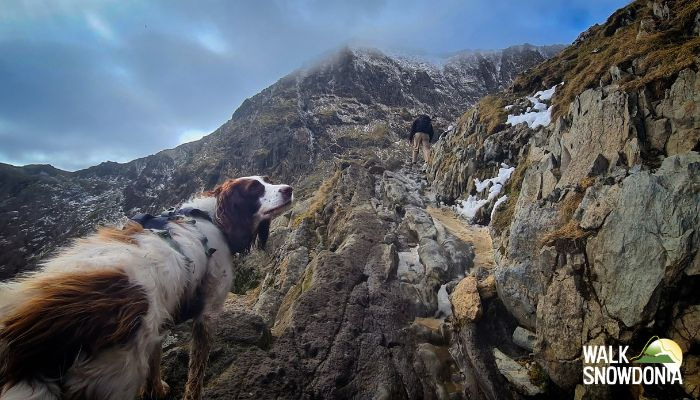
Pen y Pass to Bwlch y Moch - The First Section
The Pyg Track starts from the western end of the Pen y Pass car park. Look for the clear stone path heading uphill behind the building complex (toilets & Warden Centre).
The first 20 minutes are a steady climb on a well-built path and as you gain height the views of the Llanberis Pass open up behind you and to your right. On a clear morning, the light across this valley is superb.
You reach Bwlch y Moch (the Pass of the Pigs) after about 30 minutes. This is a natural rest point and an important junction. The path to the right climbs steeply toward Crib Goch. Crib Goch is a serious scramble that results in fatalities most years so avoid this. Continue straight on along the main Pyg Track.
From Bwlch y Moch you get your first views down to Llyn Llydaw far below and the full Snowdon horseshoe opens up ahead of you. It is one of the many picturesque views on this route where you will be reaching for your camera.

Bwlch y Moch to the Intersection - The Traverse
This middle section is the scenic heart of the Pyg Track experience. The path traverses high above Llyn Llydaw on a relatively level contour, with the dark cliffs of Y Lliwedd rising across the cwm (valley) and the lake stretching out far below. On still days, the reflections in the water are extraordinary.
To begin with the ground here is some of the best on the route with a well-maintained, level and obvious footpath. As you progress towards the back of the cwm the terrain deteriorates and becomes more rocky, uneven and narrow. You need may to use your hands briefly to scramble over rock steps. It is nothing technical.
For many people this section is the highlight of the day. The scale of the scenery is immense. The lakes below, the ridges above, the summit ahead.
You eventually reach the Intersection, marked by a standing stone where the Miners’ Track joins from below. This is where the two paths meet. On a busy day you will notice the trail suddenly getting a little more crowded. Remember this spot carefully. You will be coming back to it on your descent.
The Zigzags to Bwlch Glas - The Hard Part
Here is where honesty matters. The Pyg Track zigzags are the toughest section of this circular route (see image above).
The zigzag path from the Intersection up to Bwlch Glas covers roughly 800 metres of distance but climbs around 250 metres vertically. It is steep, sustained and relentless. The path zigzags up a rocky slope with loose stone or narrow ledges in places. You may need your hands for balance on the steeper sections.
This is an accident blackspot on Snowdon. Mountain rescue teams attend incidents here regularly.
The good news is that it does end. When you emerge at Bwlch Glas you will find the large Finger Stone where Crib Goch, the Llanberis Path and the Ranger Path converge. The Snowdon Mountain Railway appears here too. You have done the hard work. The summit is 15 minutes away.

Bwlch Glas to the Summit - The Top
From Bwlch Glas, a broad path leads alongside the railway track up to the summit of Yr Wyddfa. This final stretch takes around 15 minutes and feels almost like a victory lap after the zigzags.
At the top you will find Hafod Eryri, the striking summit building designed to withstand some of the worst weather in Britain. There may be a café open inside, but only when the Snowdon Mountain Railway is running (typically late March to October, weather permitting). Do not rely on it for your lunch or to get warm.
Step outside to the summit cairn and on a clear day the views stretch across Eryri (Snowdonia) in every direction. You can see Anglesey to the north, the Llyn Peninsula to the west, and Cadair Idris to the south. On exceptional days, the faint outline of Ireland and the Wicklow Mountains appears across the Irish Sea. Enjoy the views. You have earned it.
Descending via the Miners’ Track
For the return leg, the Miners’ Track descent is recommended to make this a Snowdon circular walk.
The upper section is steep but the gradient eases significantly after Glaslyn (lake) onwards where the walk becomes a gentle, lake-filled stroll.

Summit to the Intersection: Finding the Right Path Down
From the summit, retrace your steps down to Bwlch Glas and the large Finger Stone. Turn right, dropping steeply to leave the railway and begin descending the upper Pyg Track path, the same way you came up through the zigzags.
After a short descent, look carefully for the standing stone at the Intersection. This marks where the Miners’ Track splits off to the right on the descent and drops down toward the lakes (see image below for standing stone and Miners Track).
This is a critical navigation point. In poor visibility, this junction is commonly missed and can lead to Mountain Rescue incidents. The grid reference for the Intersection is SH 614 548.
If you are not confident with navigation in poor conditions, this is exactly the kind of situation where walking with a guide makes all the difference.

The Steep Descent to Glaslyn
The upper section of the Miners’ Track from the Intersection down to Glaslyn is the steepest part of the route. The path drops sharply over rocky, loose ground and your knees will know about it. Walking poles are a genuine help here.
Take your time and watch your footing. After 20 to 30 minutes of careful descent, the gradient eases and you arrive at the shores of Glaslyn lake, one of the most photographed spots in Snowdonia (Eryri).
The lake’s distinctive blue-green colour comes from dissolved copper minerals, a legacy of centuries of mining in the cwm above. According to legend, this is where Sir Bedivere threw King Arthur’s sword Excalibur into the water.

Glaslyn to Pen y Pass: The Scenic Return
From Glaslyn, the path improves dramatically. You follow the shoreline before a gentle descent brings you down to Llyn Llydaw, the larger of the three lakes (see image above).
Walking along the shores of the lake is easy and relaxed, a welcome change after the steep ground above.
The highlight of this section is crossing the Llyn Llydaw causeway (built 1853). This stone causeway cuts straight across the lake with water on both sides and the mountains rising all around you. It is one of those moments where you stop, look around, and realise why you came to climb Snowdon.
The final 1.5 km back to Pen y Pass is a very easy, flat stroll along a well-made track which used to service the old copper mine, a reminder that this landscape was once an industrial workplace.
Follow the track with the Glyderau mountains ahead, Moel Siabod to your right and the satisfaction of a brilliant day settling in.
Guided Pyg Track and Miners’ Track walk
We take the stress out of parking, navigation and route-finding so you can focus on the views. Find out more and book your guided walk
How Long Does the Pyg/Miners Circular Take?
Most walkers complete the Pyg Track and Miners’ Track circular in 5 to 7 hours. A typical breakdown is 2.5 to 3.5 hours ascending via the Pyg Track, 30 minutes at the top, and 2 to 3 hours descending via the Miners’ Track.
Several factors affect your timing. Fitness is the obvious one, but weather plays a big role too. Wet, windy conditions can slow everyone down considerably. Good weather means better views and more photo stops.
If this is your first big mountain walk, give yourself plenty of daylight. Starting early also means you are more likely to have the Pyg Track to yourself before the crowds arrive.
For more detail on Snowdon timings across all routes, take a look at how long Snowdon takes
What to Pack for the Pyg & Miners’ Track
Getting your kit right makes the difference between a great day and a miserable one.
Waterproofs are essential. Snowdon (Yr Wyddfa) has its own weather and a sunny day at Pen y Pass can turn to driving rain at the summit moments later. Bring a waterproof jacket and ideally waterproof trousers.
Walking boots or good trekking shoes with good grip are essential. Ankle support will reduce the risk of injury. The Pyg Track and the upper section of the Miners’ Track are rocky and uneven. We see people slipping around and getting injured in inappropriate footwear regularly. Read our summer kit guide for more detail
Water: carry 1.5 to 3+ litres. There is no reliable water source on the route and the summit café is not always open. On hot days you will drink more than you expect.
Food and snacks for the whole day. Energy bars, sandwiches and a treat for the summit. See our guide on what food to take up Snowdon for ideas.
Navigation: a paper map (OS Explorer OL17 from Ordnance Survey) and a compass are ideal if you know how to use them. Your phone is a useful backup.
Walking poles are helpful, especially for the Miners’ Track steep descent. They take significant pressure off your knees on the way down.
In summer: sun cream, sunglasses and a sun hat. UV exposure at altitude is higher and catches people out.
In winter: this route often requires crampons, an ice axe and experience to stay safe. Snow and ice can linger on the zigzags well into April. Read our winter kit list for Snowdon before attempting a winter ascent.
For general mountain safety advice, Adventure Smart Wales is an excellent resource backed by mountain rescue teams across the UK.
When to Avoid This Route
Knowing when not to climb Snowdon is just as important as knowing how. Here are the times to think twice venturing out.
Winter conditions. Snow and ice transform the zigzags and the upper Miners’ Track into serious mountaineering terrain. People die on Snowdon in winter conditions. You should only head out in these conditions if you know what you're doing.
Poor visibility without navigation skills. The route is not obvious, there are no signposts and the Intersection junction is easily missed. Getting lost here can be serious. Check the Met Office Yr Wyddfa summit forecast before every walk.
Summer bank holiday weekends, unless you start very early. Our Snowdon sunrise guide covers how to plan an early start and avoid the crowds.
Best months for the Pyg/Miners circular: May, June and September give you the best balance of decent weather, longer daylight and fewer crowds. October can also be excellent, with autumn colour across the cwm and the paths noticeably quieter than summer.
Most of the photos in this blog were taken in spring or autumn.
Can Beginners Do the Pyg Track and Miners’ Track?
Yes, but with honest caveats.
They Pyg & Miners track is a mountain track in an environment where hazards can't be removed. Like all mountain walking there is an element of risk, which includes a danger of personal injury or death.
In 2025 there were 358 incidents involving Mountain Rescue on Snowdon - an average of nearly one a day.
The Pyg Track and Miners’ Track circular is harder than the Llanberis Path, which is the most straightforward route to the summit. Is the Pyg Track hard? It demands reasonable fitness, confidence on rocky and uneven ground.
The 'scrambling' on the Pyg Track is brief and not technical (below Grade 1 so technically still a 'walk'). It simply requires care and a 'normal' tolerance of heights.
If you walk regularly, can handle 5 to 7 hours on your feet, and are not fazed by steep, rough terrain, can navigate with a map and compass, are well equipped then you have a good chance of managing the Pyg & Miners Track in the right conditions.
Is the Miners’ Track easier than the Pyg Track?
The lower section of the Miners’ Track (from Pen y Pass to Llyn Llydaw) is considerably easier than the Pyg Track and almost flat. It is one of the easiest sections on any footpath on the mountain. However, the upper section between Glaslyn and the Intersection is steeper and often rougher than any section of the Pyg Track.
So which is harder, Pyg or Miners? The Pyg Track is more sustained. It is also harder than the lower section of the Miners Track but easier than the upper section of the Miners Track. The upper section of the Miners Track is harder than any section of the Pyg Track.
Using each path in the recommended direction (Pyg up, Miners down) plays to the strengths of both.
If you are genuinely anxious about difficulty or this is your first mountain walk, the Llanberis Path is a gentler alternative. Read our beginner’s guide to Snowdon for a full comparison of routes.
If you are unsure about your fitness levels you might also find it helpful to read about how to train for climbing Snowdon
For less confident walkers, a guided walk can transform the experience. Having an experienced Mountain Leader alongside you takes the anxiety out of the day entirely.
Someone who knows every metre of the path, adjusts the pace, points out the best footholds on the scrambles, and handles the navigation, will make the day enjoyable and memorable for the right reasons.
Why Walk with a Guide?
A guided walk on this route is not about being led by the hand. It is about getting more from the day.
Walk Snowdonia’s Mountain Leaders are all excellent mountain professionals with bags of experience. They are qualified, insured, first aid trained and live in the shadow of Yr Wyddfa (Snowdon). They know this circular route intimately and have led it in every season and every kind of weather.
A guide point out things you would otherwise walk past and will be able to answer your questions.
There is a practical side too. The guiding company manages the logistics, from parking advice to pace management, and navigates the tricky footpath so you never have to worry about taking a wrong turn. On the zigzags, they will show you the best line and make sure everyone in the group is comfortable and safe.
Most of all, walking with a guide means you can stop thinking about the route and simply enjoy where you are. On a route this spectacular, that is worth everything.


