

Best easy walks in Snowdonia (that aren't mountains)
- Apr 22, 2024
- 11 min read
The mountains of Eryri (Snowdonia) are spectacular and we love climbing them but you don't need to be at the top of a towering peak to appreciate the raw beauty of the natural surroundings. Some of the best views and natural attractions such as verdant forests, tranquil lakes and epic waterfalls can be found lower down and are quick and easy to access.

Some of the best short walks with incredible views in Snowdonia National Park are...
Aber Falls
Cwm Idwal
Swallow Falls
Precipice Walk
Llyn Elsi
Crimpiau
Coed Ganllwyd
Fishermans Path & Cwm Bychan
What is an easy walk in Snowdonia?
The difficulty of walks is subjective. The level at which a walk moves beyond 'easy' varies from person to person and even day to day. Most individuals with an average level of fitness will find these walks 'easy' or 'moderate'. They can be completed in a few hours at a leisurely walking pace, don't exceed 610m (the height of a mountain in the UK) and are relatively easy under foot (on good footpaths).
In addition to being at the lower end of difficulty we have chosen walks based on their natural beauty with all of them having points of interest and stunning views.
The walks listed are roughly in order of difficulty starting with the easiest. Consider hiring a guide to take the stress out of route finding and to enrich your day with interesting facts and local information

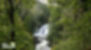
1. Aber Falls
One of Snowdonia National Park's most awe-inspiring sights is easily accessed via a good footpath.
Aber Falls/ Rhaeadr Fawr (black falls in English) is an impressive waterfall which plunges a huge 37 meters into a deep plunge pool. It is particularly good after heavy rain. The walk is one of the shortest Snowdonia has to offer and the picnic areas with wide open spaces make it a perfect walk for children and young families.
At a glance
6.7km
2 hours
Circular route
Waterfall & historical interest
Route Description
From the car park head into the woodland following the Afon Rhaeadr Fawr river upstream. Use the bridge to cross the river joining the main path up the valley. The very well maintained gravel path continues at a gentle incline with glimpses of the impressive waterfall.
Historical interest is added just before reaching the waterfall as you pass an iron age hut circle which was built around a bronze age standing stone. It is easy to see why this location has been popular for thousands of years.
After standing in awe at the powerful waterfall, cross the river and continue at a slight incline into moorland before heading north along the North Wales Pilgrim's Way. When the footpath forks (about 700m after the powerlines) take the right-hand route towards Abergwyngregyn. From the village follow the road back up to the car park.
Alternative Routes
After visiting the powerful waterfall the easiest route is to retrace your steps back down the valley (4.4km) as a there and back route.
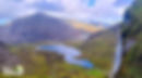
2. Cwm Idwal Circular Route
The small glacial valley of Cwm Idwal is breathtaking. Surrounding a beautiful lake are impressive rocky cliffs including the Idwal Slabs, Twll Du (Devil's Kitchen) and some of the biggest and best mountains in Wales.
In 1954 Cwm Idwal became the first National Nature Reserve in Wales due to its wildlife habitats and geological features. In 2005 Cwm Idwal was ranked the 7th greatest natural wonder in Britain.
At a glance
4.2km
2 - 3 hours
Circular route
Mountains, lake, streams
Route Description
The walk starts at the Ogwen Cottage Visitor centre which sells snacks as well as hot & cold drinks. From here the footpath crosses a stream and continues up a gentle but noticeable incline for around a kilometre gaining 140m of height.
At the top of the climb you will be rewarded with awe inspiring views of the Cwm Idwal lake & valley as well as the Devil's Kitchen.
Follow the footpath around the lake. There are two footpaths at the back of the lake; a higher and more difficult option or an easier and lower option keeping close to the lake.
Alternative Routes
The walk can be extended by adventurous hikers up to Llyn y Cwn (The Dog Lake) or Llyn Bochlwyd or even into the Glyderau mountain range for a proper adventure.
3. Swallow Falls
A straightforward walk through enchanting woodland following the Afon Llugwy river as it cascades down to the beautiful village of Betws-y-Coed.
A gentle descent alongside the river through one of the most beautiful valleys in Snowdonia. This walk passes the Swallow Falls waterfall, Ugly House Cafe as well as Betws-y-Coed's bridges.
At a glance
4.5 km
2 hours
Linear route
Woodland, waterfall, pub, café
Route Description
Catch the bus from Betws-y-Coed to Ty-hyll/ Ugly House Café. Use the style to cross the wall and follow the Snowdonia Slate Trail and Afon Llugwy river east and downstream.
Enter ancient woodlands along a cobbled footpath before crossing another style into an open field. Dogs must be kept on a lead here.
Follow the footpath through the field into the woods at the back. The footpath then heads gently downhill until reaching the impressive waterfalls of Swallow Falls.
Continue along the path past small cliffs on the left until you reach a minor road. Follow the road for around a kilometre until a footpath leads to the Miners Bridge.
From here follow the river for around 1.5km until you reach the Pont y Pair bridge in the middle of Betws-y-Coed.
Alternative Routes
A much shorter variation is from Betws-y-Coed to the Miners Bridge (1.3km).
Alternatively the walk can be extended by starting at Capel Curig (10 km). This variation is no more difficult, just a bit longer, and starts by adding fantastic open views of the surrounding countryside before entering the woodland. Another benefit of this extension is that the Ugly House Cafe is now the halfway point allowing you to enjoy a slice of well earned cake before burning off the calories on the second half of the walk for a guilt free indulgence.

4. Precipice Walk
A short walk with very little climbing as you contour around two hills taking in Llyn Cynwch lake. This walk has spectacular views of Snowdonia's mountains as well as the Mawddach Estuary.
At a glance
5.8km
2 hours
Circular route (signposted)
Lake, mountain views, sea views, woodland, hill fort
Route description
Head uphill through Coed y Groes woods and into open fields with excellent views. Contour around Foel Cynwch and Foel Faner maintaining height as Mawddach Estuary gets closer.
As you make progress Cadair Idris will gradually reveal itself before a short descent to the banks of Llyn Cynwch lake. From here take the footpath back through the woods.
Alternative Routes
It is worth taking a small detour to head up to the iron age hill fort at the top of Foel Faner.

5. Llyn Elsi
The tranquil Llyn Elsi lake is situated amongst mixed broadleaved and fir woodland above the picturesque village of Betws-y-Coed.
The walk is never challenging and offers pleasant views down the Vale of Conwy as well as fantastic views of the surrounding countryside from the clearing around the lake.
At a glance
6.5km
3 - 4 hours
Circular route
Forest, lake, pubs, cafés
Route Description
Head towards the woodland at the back of St Mary's Church and follow the forestry track in a westerly direction keeping to the main track as you pass through lush woodland.
This will eventually bring you to the clearing with views of the idyllic lake and surrounding mountains including an excellent view of Moel Siabod which translated into English means 'Shapely Hill'. We certainly think it's lines are pleasing.
From here there are lots of footpaths but the best takes you around the lake and back down the Jubilee Path which has unparalleled views down the Vale of Conwy. This is particularly good on a damp autumn morning as all manner of mushrooms burst out of a carpet of thick moss.
Alternative Routes
A good extension is over the Miners Bridge and along the Afon Llugwy river back into the village (7.8km) or there are lots of forest tracks to explore including the cobbled Roman Road 'Sarn Helen' (9km). The name comes from St Elen of Caernarfon, who is said to have commissioned the road in the 4th century.

6. Crimpiau
If you want the sense of achievement of 'bagging' a summit without actually climbing a mountain then Crimpiau is the perfect walk. The summit only rises to 475m but it punches well above it's weight.
Situated on the south east of the Carneddau range this walk has a mixture of habitats. You will pass through native woodland, heathland and open moorland as well as a small lake. The summit has commanding views of many of the National Parks biggest peaks and best valleys including Snowdon, Tryfan, Mymbyr valley, Ogwen valley and Conwy valley.
At a glance
6km
4 hours
Circular route
Woodland, moorland & heathland, extensive views
Route Description
From the village of Capel Curig, head east along the Snowdonia Slate Trail crossing a series of small streams until you reach an ancient woodland of moss covered rocks and luscious lichens. Continue through the woodland to a fallen tree then instead of continuing along the footpath head up a steep fern covered slope for a pleasing circular route.
Cross a style and then enter open heathland and moorland as you follow the 'ridge' in a north easterly direction. As you gain height the views get increasingly impressive and you will pass the small Llyn Corun lake. From here the summit is less than a kilometre away. You will be rewarded with incredible views for very little climbing.
From here head back along the substantial footpath in the valley for a brilliant circular walk.
Alternative Routes
Continue to the next peak 'Craig Wen' which is still not a mountain at 548m but is certainly starting to feel like it.
The really adventurous can continue onto Moel Ddefaid, Craiglwyn and eventually Creigiau Gleision (678m). This extension is definitely mountain walking and although it is not 'easy' it is one of the best, least trodden and gentle mountain walks in Snowdonia.

7. Coed Ganllwyd Walk
A beautiful riverside walk in South Snowdonia taking in the turbulent River Gamlan and it's cascading Rhaeadr Ddu waterfalls.
At a glance
5.3km
2 hours
Circular route (signposted)
Waterfalls, woodland, extensive views
Route Description
This walk starts near the confluence of the Afon Mawddoch and Afon Gamlan. Follow the road and cross the River Gamlan before taking the footpath upstream to view a series of cascading waterfalls known locally as the Rhaeadr Ddu (Black Falls).
Near the bridge is a poem inscribed on a rock which was inspired by the falls. Leave the river and falls and head south, deep into the celtic forest. The mixed oak woodland was at the heart of a vast temperate rainforest which covered much of western Britain.
Exit the rainforest and continue uphill to the ruins of Cefn Coch gold mine and extensive views before heading back towards the rainforest and waterfalls.
Alternative Routes
The route can be shortened considerably by just visiting the Rhaeadr Ddu waterfalls which start immediately after leaving the road.

8. Fisherman's Path & Cwm Bychan
Striking and varied scenery awaits on this fabulous walk. Pass through a series of diverse natural environments as well as Snowdonia's mining heritage.
This walk has it all with extensive views of the Snowdon range, the Irish sea, rivers, lakes, forests, a deep gorge and historical interest. This is one of our favourite walks.
At a glance
10km
5-6 hours
Circular route
Heathland, woodland, rivers, lake, gorge, historical interest, pub & cafe's
Route Description
The walk can be started from Nantmor car park, Llyn Dinas car park or the village of Beddgelert.
From the village of Beddgelert follow the Cambrian Way northeast towards Sygun Copper Mine. Continue past the mine and follow the river upstream along an excellent footpath, passing Dinas Emrys until reaching Llyn Dinas lake.
From the lake the route changes as it heads uphill into moorland joining the Afon Goch stream until Grib Ddu where the views are excellent. From this highpoint it is a pleasant stroll down Cwm Bychan, a valley rich in mining heritage, into Nantmor woods where the scenery changes completely again.
Pass under the railway bridge and follow the Ffestiniog Highland Railway through the epic Aberglaslyn Pass back into the quaint village of Beddgelert.
Alternative Routes
Numerous variations of the route exist. The easiest option is the Gelert's Grave Walk from Beddgelert via a very accessible path (0.5 km).
For a more challenging walk head straight up Mynydd Sygyn for the most extensive and inspiring views of the mountains (including Snowdon). Alternatively, you could miss out the uphill sections entirely and just walk along the Afon Glaslyn river.

9. Llyn Dinas Circular Walk
This moderate walk takes in the best of the Nantgwynant valley as well as the lower and easier section of Snowdon's Watkin path.
The route takes in varied terrain with stunning views of Llyn Dinas lake, Snowdon's waterfalls and ancient Celtic Woodland. Never exceeding 320m in height it has a real mountain feel and is a great alternative to the full Watkin Path in poor weather.
At a glance
11km
6 hours
Circular route
Lake, river, woodland, waterfalls, moorland, café
Route Description
Starting at Llyn Dinas car park, cross the road and head towards the lake. Turn left after crossing the small bridge to reach the lake. Follow the Cambrian Way footpath along the banks of the lake for a short while. The footpath soon via's away from the lake continuing up the valley until you reach a minor road. Turn left at the road, cross the river then join the A498 by turning right. Follow the road less than 300m past Cafi Gwynant before leaving the road and heading up the steps at the start of the Watkin Path.
Follow the path through woodland and over a couple of small bridges. After leaving the woodland the views open up and you will get stunning views up the Nantgwynant valley. Follow the Afon Cwm Llan upstream with excellent views of Snowdon's waterfalls. Take the inviting footpath south west breaking away from the river and into open country and eventually down to Craflwyn Hall. Take the the road east no more than 300m before rejoining the Cambrian Way at Sygun Copper Mine. Head east back to towards Llyn Dinas lake to cross the bridge back to the car park.
Alternative Routes
A much shorter version of the Llyn Dinas walk is to walk the length of the lake as a there and back route (3.5km).
Alternatively, start at Bethania pay & display car park near Cafi Gwynant and head straight up the Watkin Path to the Snowdon Waterfalls.

10. Gwydir Forest, Llyn-y-Parc & Afon Llugwy
This woodland circular walk takes in some of the best natural attractions in the National Park including big lakes and beautiful rivers as well as several old lead and zinc mines which were prominent in the area.
The walk mainly follows forest roads but also includes narrow tracks and steep sections.
At a glance
9.7km
5 hours
Circular route
Woodland, mines, lake, river, waterfalls, Cafés & pubs
Route Description
The route starts in the village of Betws-y-coed and immediately heads into Gwydir Forest. This gets the heart pumping as it is steep at first but soon eases.
At just over a kilometre you will reach the ruins of Aberllyn Lead Mines which were last worked in the 1920's. After this you will pass a cascading waterfall before reaching the impressive Llyn-y-Parc lake.
Walk along the water's eastern edge and continue past Parc Lake and Coed Mawr Pool Lead Mine's and head in a southerly direction until reaching the Afon Llugwy River and Miners Bridge (pictured). Follow the river back into the village for a well deserved drink.
Alternative Routes
The walk could be shortened by around a third with a simple there and back to Llyn-y-Parc lake. You could also make it longer by spending a lot of time exploring the many forest tracks in Gwydir Forest.
FAQ's
Walks with pubs
There are lot's of nice pubs in Snowdonia's villages. Beddgelert and Betws-y-Coed have some of the nicest pubs and walks.
The Swallow Falls, Llyn Elsi, Fisherman's Path & Gwydir Forest walks all end at a village with a nice pub.